


RC3000 Antenna Controller Chapter 3 Detailed Operation
87
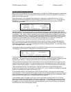
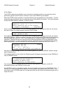
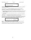
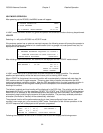
GPS Lat/Lon
37°36N 97°18W WICHITA LAT/LON
GPS:38°56N 94°44W 17:36:59
<ENTER>USE GPS LAT/LON <BKSP>EXIT
The current lat/lon the gps has calculated is displayed. The UTC the gps is outputting is also displayed to
show that the data is being updated. To select this lat/lon press the Enter key. Note that if the gps is not
reporting a valid position fix the message “WAITING FOR GPS” will appear.
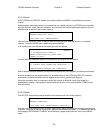
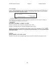
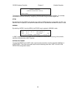
3.2.2.7.2 HEADING
When the user chooses to modify heading, a screen appears showing the current heading (HDG:) and
source (SRC:) of heading. If valid heading data is coming from the fluxgate, this data will appear in the
FLUX HDG: field. The MAG VAR: field displays the calculated magnetic variation for the current
lat/lon/date. If the RC3000 thinks it needs to recalculate magnetic variation (thinks lat/lon has changed)
the MAG VAR: field will flash “CALC”. The magnetic variation calculation may take up to 10 seconds.
FLUX HDG:214.3 HDG:180.0 HEADING
MAG VAR: 3.8 SRC:MANUAL
AZ OFF: 0.0 <1>MAG <2>TRU <3>COMPASS
TRUE HDG:218.1 SELECT SOURCE <MODE>EXIT
To modify the heading to the value determined via the fluxgate (flux heading + azimuth offset +mag var)
press the 3 key.
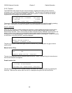
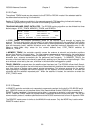
If the user wishes to enter a magnetic heading of the vehicle press 1.
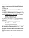
MAG HDG=> HDG:180.0 HEADING
MAG VAR: 3.8 SRC:MANUAL
AZ OFF: 0.0 <1>MAG <2>TRU <3>COMPASS
TRUE HDG: **** SELECT SOURCE <MODE>EXIT
After the magnetic heading is entered, the RC3000 will apply the magnetic variation and azimuth offset to
generate the true heading of the mount’s azimuth centerline.
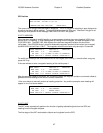
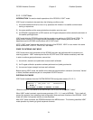
If the user wishes to manually enter true heading press the 1 key and the prompt to enter heading will
appear on line 3 as shown below.
FLUX HDG:214.3 HDG:180.0 HEADING
MAG VAR: 3.8 SRC:MANUAL
AZ OFF: 0.0 ENTER HDG=>
TRUE HDG:218.1 SELECT SOURCE <MODE>EXIT
3.2.2.7.3 INIT
The INIT mode automatically performs the function of getting latitude/longitude from the GPS and
heading from the fluxgate compass.
The first stage of the INIT mode obtains latitude and longitude from the GPS.