


RC3000 Antenna Controller Chapter 3 Detailed Operation
77
If the navigation sensors (GPS and/or compass) are not working (or not available), the position
information may be entered manually via the POSITION mode (3.2.2.7).
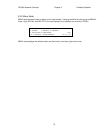
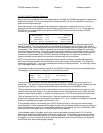
SAT: GALAXY 6 74.0W
<1>SELECT NEW SAT
The SAT: field shows the currently selected satellite’s name and longitude. When the mode is first
entered the name of the last satellite selected will be displayed. If the user wishes to locate another
satellite, he may start the process of selecting the new satellite by pressing the "1" key. See 3.2.2.3.1 for
further details on the three methods of selecting a satellite.
When the selected satellite is changed the LOCATE mode will automatically calculate new azimuth and
elevation pointing targets.
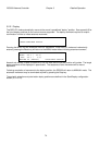
AZ: -31.1
EL: 40.0
These fields show the azimuth and elevation pointing angles calculated for the selected satellite based on
the current mount position estimate. If one of the required parameters is missing or the calculation has
yielded an invalid answer, asterisks will be displayed in these fields.
NOTE: the displayed AZ target is not a true heading display but rather a mount-relative angle. The
elevation target is a true elevation value.
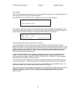
MAG:/TRU:
If the user wishes to display a magnetic or true heading pointing solution (rather than antenna relative),
he may choose how the azimuth data is presented by changing the initial_azimuth_display configuration
item via the Azimuth Calibration (3.3.1.2.3) screen.
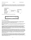
Location Readiness Status
In the lower right corner of the display, a message is displayed showing the status of the location
calculation. Three messages may be displayed:
1) PARAMETER NEEDED. The pointing angle calculation requires 3 sets of data a) vehicle lat/lon
b)vehicle heading and c)satellite information. If lat/lon and/or heading is missing/invalid, the user will
need to go to POSITION mode to enter valid data. If satellite information is missing/invalid, the user will
need to supply that information via the mechanisms described in 3.2.2.3.1.
2) AZIM/ELEV RANGE ERROR. If the pointing solution calculation yields an azimuth angle that is
outside the clockwise or counter-clockwise azimuth limit (3.3.1.2.3) or outside the up or down elevation
limit (3.3.1.2.2), one these messages will be displayed to indicate that the RC3000 does not think it can
move the antenna to the correct position to acquire the satellite. The user may have to move the vehicle
to place it in an orientation that will allow the mount to move to the required position. Note that this
message may indicate that the current position data is incorrect (example: wrong heading).
3) READY TO LOCATE / PRESS <ENTER>. This alternating message indicates that the RC3000
considers the calculated pointing solution valid. Pressing the Enter key will initiate automatic movement
to find the selected satellite as described in 3.2.2.3.2.
3.2.2.3.1 Satellite Selection
Several pieces of information must be provided to describe a satellite to the RC3000 before the satellite
may be automatically located (and subsequently stored, recalled, tracked,etc):
NAME: up to 10 characters (A-Z, 0-9, space)