


Following your Flight Plan
When you have created and started your flight plan (or route), the
GPSMAP 296 guides you to the destination using a variety of tools.
NOTE: After you perform an update to your Jeppesen Database,
verify that all of your flight plans (routes) in your unit are still
current. If there is an obsolete Jeppesen aviation point in a saved
route, the route is locked and unusable. You need to create a new
route with current Jeppesen Database points.
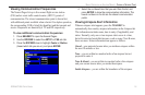
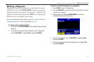
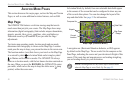
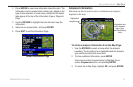
Track Your Progress on the Map Page
On the Map Page, your current location is shown as an airplane (when
in Aviation Mode). You can see how the airplane moves across the
map; this is a graphic view of your flight. Your route is marked with a
magenta line. The airplane should be on top of the magenta line as you
move. When you are on the magenta line, you are directly on course.
NOTE: In Aviation (and Marine) Mode, the Go To line and
navigation guidance are fixed. The From point is the location
where the Go To was initiated. In Automotive Mode, the Go To
line on the map is constantly updated to your present location.
For complete information about the Map Page and the features of
the Map Page, see “Map Page,” beginning on page 28.
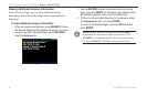
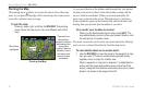
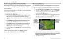
Terrain and Obstacle Changes
Press PAGE to open the Terrain Page, and watch the changes in the
terrain and the obstacles you are flying over with the Terrain Page.
Terrain and obstacles that are less than 100 feet from your aircraft are
shown in red. For complete information, see page 36.
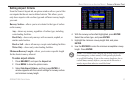
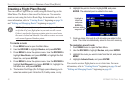
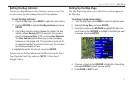
View the HSI on the Panel Page
You can use the Panel Page to view the HSI, your bearing to the course,
and other information such as speed, altitude, and ETA.
Use the compass in the center of the page to determine if you are on the
proper course. Also, you can help keep the aircraft within the VNAV
profile when viewing the VNAV indicator.
For complete information about the Panel Page, see the section
“Panel Page,” beginning on page 39.
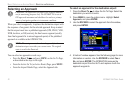
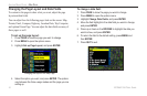
Alerts
As you travel, a variety of alerts appear on your current page, such as
Airspace, Terrain, Obstacle, and Descent Rate Alerts. When an Airspace
Alert pops up, press NRST to view the Airspace Information.
When a Terrain or Obstacle alert pops up, press
NRST to open the
Terrain Page. From here you can view any terrain and obstacles that
might become a problem to you. Possible points-of-impact are shown
as Xs. Adjust your altitude to avoid the obstacles
and terrain.
GPSMAP 296 Pilot’s Guide 27
BASIC OPERATION IN AVIATION MODE > FOLLOWING YOUR FLIGHT PLAN