


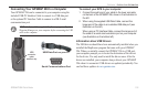

Learning About GPS
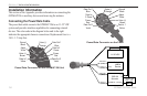
The Global Positioning System (GPS) is a satellite-based navigation
system made up of a network of 24 satellites placed into orbit by the
United States Department of Defense.
GPS was originally intended for military applications, but in the
1980s, the government made the system available for civilian use.
GPS works in any weather conditions, anywhere in the world, 24
hours a day. There are no subscription fees or setup charges to use
GPS. For more information refer to the Garmin Web site at www.
garmin.com and also read the GPS Guide for Beginners, which can
be found on the Web site at
http://www.garmin.com/aboutGPS/manual.html.
Common GPS Terms
Initialize—the first time a GPS receiver orients itself to its current
location and collects data. After the receiver is initialized, it
remembers its location and acquires a location more quickly.
Location—an exact, unique location based on geographic
coordinates (Latitude and Longitude).
Route—A group of waypoints entered into the GPS receiver in the
sequence you want to navigate them.
Waypoint
—a location you store in your GPS.
What is Differential GPS (DGPS)?
The United States and Canadian governments (among others) have
set up Differential GPS (DGPS) stations to transmit correction
signals. They are operational in coastal areas and on many navigable
river systems.
The DGPS system is available for use without a fee, but you do need
additional equipment to receive DGPS signals: A beacon receiver
compatible with the RTCM format sentences supported by your
Garmin GPS is needed to use DGPS.
Refer to the United States Coast Guard’s Web site (
http://www.
navcen.uscg.gov/) for locations and status of the differential stations.
Differential Field
Differential receiver status is indicated in the bottom left field of the
GPS Page and shows one of the following conditions:
• None—no optional beacon receiver is attached or enabled
on the Interface sub tab on the Main Menu or WAAS is
turned off.
• Searching for WAAS—WAAS is enabled and the receiver is
searching for WAAS signal.
• Using WAAS—WAAS capability is enabled and the unit is
receiving WAAS corrections.
138 GPSMAP 296 Pilot’s Guide
APPENDIX > LEARNING ABOUT GPS