


Jeppesen Database Information
The GPSMAP 296 includes an internal Jeppesen
®
database that
provides location and facility information for thousands of airports,
VORs, NDBs, and more. Updates to the Jeppesen database are
available every 28 days online www.garmin.com. The update
program is designed to operate on Windows
®
-compatible PCs and
requires the included PC Interface Cable to connect your GPSMAP
296 to the PC’s serial communications port. The following
information is provided from the internal Jeppesen database:
Airport—* identifier, facility name, city/state/country, latitude/
longitude, field elevation, available fuel types, runway designations
and layout, runway surface, runway length, runway width, runway
lighting, communication frequencies, and published approaches.
Weather—frequencies associated with an airport (ASOS, ATIS, and
AWOS).
VORs—* identifier, facility name, city/state/country, location
(latitude/longitude), frequency, service volume (high, low, terminal),
and type (such as VOR-DME, TACAN, and VORTAC).
NDBs—* identifier, facility name, city/state/country, location
(latitude/longitude), and frequency.
Intersections—identifier, nearest VOR, radial and distance from
nearest VOR, location (latitude/longitude), and region/country.
ARTCC—Air Route Traffic Control Centers.
Airspace—boundaries (Class B, Class C, Control Zones, SUAs, and
MOAs), controlling agency, and vertical boundaries.
FSS—Flight Service Stations.
* Symbology used for NDBs, VORs, and airports is consistent with
those used on a sectional chart.
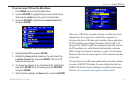
Database Updates
Updates to the Jeppesen database are available every 28 days online
(http://shop.garmin.com/aviation/databases/). The update programs
are designed to operate on Windows
®
-compatible PCs and requires
the included USB Interface Cable to be connected to the unit and an
available USB port on your computer.
NOTE: After you perform an update to your Jeppesen database,
verify that all of your flight plans (routes) in your unit are
current. If there is an obsolete Jeppesen aviation point in a saved
route, the route is locked and unusable. You need to create a new
route with current Jeppesen database points.
An optional FlightBook software package is available to assist with
your flight record keeping. Visit the Garmin Web site at
http://www.garmin.com/aviation.
GPSMAP 296 Pilot’s Guide 145
APPENDIX > JEPPESEN DATABASE INFORMATION