


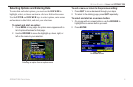
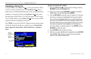
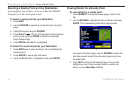
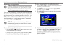

Finding a Nearby Point
In Aviation Mode, press NRST/FIND to open the Nearest Pages.
These pages provide detailed information on the nearest airports,
airport weather sources, user waypoints within 200 miles of your
present location, and other points.
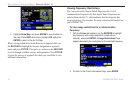
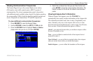
In Marine and Automotive Modes, press
NRST/FIND to open the
Find Menu. You can easily search waypoints, cities, exits, and tide
stations using the Find Menu.
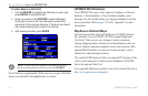
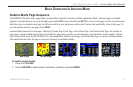
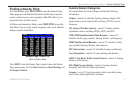
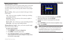
Nearest Page: Airport Tab
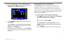
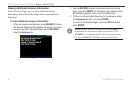
While in Aviation Mode
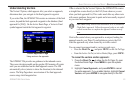
Press MENU when the Nearest Page is open to show the Nearest
Page options menu. You can Show Arrows (or Show Bearing) and
Set Airport Criteria.
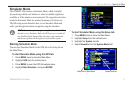
Aviation Nearest Categories
In Aviation Mode, the Nearest Pages contains the following
information:
Airport—nearest 15; identifier, bearing, distance, length of the
longest runway, and common traffic advisory (CTAF) or tower
frequency.
WX (Airport Weather Sources)
—nearest 15 airport weather
information sources including AWOS, ASOS, and ATIS.
VOR (VHF Omnidirectional Radio Beacons)
—nearest 15;
identifier, facility type (symbol), bearing, distance, and frequency.
NDB (Non Directional Beacons)—nearest 15; identifier, facility
type (symbol), bearing, distance, and frequency.
INT (Intersection)—nearest 15; identifier, bearing, and distance.
User (Waypoints)
—nearest 15; name, bearing, and distance.
ARTCC (Air Route Traffic Control Center)
—nearest 5; bearing,
distance, and frequency.
FSS (Flight Service Station)—nearest 5; bearing, distance,
frequency, and VOR (for duplex operations).
Airspace—up to 15 (based on number of alerts provided); name,
time to entry (when applicable), and status.
GPSMAP 296 Pilot’s Guide 17
BASIC OPERATION IN AVIATION MODE > FINDING A NEARBY POINT