


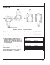
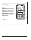

Original GreenStar Display—StarFire iTC
OUO6050,0002266 –19–14NOV06–1/2
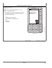
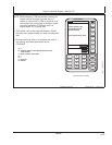
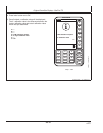
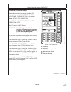
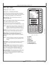
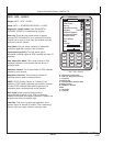
INFO - GPS - PAGE 1
7
4
1
0
5
2
9
6
3
.
8
CLR
SETUP
PAGE
RUN
INFO
JOHN DEERE
A
B
C
D
E
F
G
GPS
00:35:17
GMT
Lat NoNav
Lon NoNav
Altitude (ft) NoNav
GPS Course
GPS Speed (mph)
Position Mode
Differential Mode
GPS Accuracy Indicator
GPS Signal Quality
Diff Signal Quality
INFO
PAGE 1
8/22/1999
0%
0%
0
NoNav
0.0
0
0
None
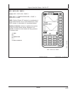
PC9576 –UN–06NOV06
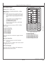
INFO - GPS - PAGE 1
A—Latitude
B—Longitude
Altitude
C—GPS Course
GPS Speed
D—Position Mode
Differential Mode
E—GPS Accuracy Indicator
F—GPS Signal Quality
G—Differential Signal Quality
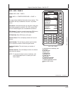
Screen: INFO - GPS - PAGE 1
Press: INFO >> STARFIRE RECEIVER
This screen shows information and status of incoming
GPS and differential correction signals. No information on
this screen can be changed. It is for viewing only.
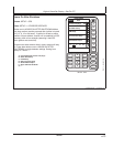
Date and Time: This cell shows date and time for
Greenwich Mean time.
Lat: This cell displays vehicle location latitude coordinates
with respect to Equator (north or south).
Lon: This cell shows vehicle location longitude
coordinates with respect to Prime Meridian (east or west).
NOTE: Toggle button allows operator to change the way
latitude and longitude are displayed between
degrees, minutes, seconds and decimal degrees.
Altitude: This cell shows height of receiver, measured
from top of dome, in meters (feet) above sea level.
GPS Course: This cell displays direction of travel, in
degrees, relative to true north (zero degrees) as
measured by receiver. Angle is measured in clockwise
direction.
NOTE: Course and speed normally show small speeds
and various courses even when machine is not
moving.
GPS Speed: This cell shows ground speed of machine in
kilometers per hour (mile per hour) as measured by
receiver.
Position Mode: This cell indicates whether receiver is
calculating a 3D position, 2D position, or no position (no
nav). It also shows status of differential signal: SF 1
(StarFire 1 differential), SF 2 (StarFire 2 differential).
Differential Mode: This cell shows status of GPS signal:
2-D (two dimensional with latitude and longitude of
vehicle) or 3-D (three dimensional with altitude, latitude,
and longitude of vehicle).
25-21
121907
PN=80
Continued on next page