


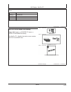
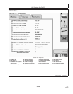

GS2 Display—StarFire iTC
OUO6050,0002248 –19–14NOV06–3/4
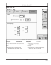
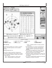
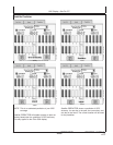
Satellite Tracking Chart
• SAT ID – (Satellite Identification Number)
Identification number for GPS Satellite.
• ELV – (Position Elevation) Elevation in degrees
above horizon for GPS satellite position
• AZM – (Position Azimuth) Azimuth in degrees from
true North for GPS satellite
• L1 SNR – (L1 Signal to Noise Ratio) Signal strength
for L1 GPS signal (signal to noise ratio)
• L2 SNR – (L2 Signal to Noise Ratio) Signal strength
for L2 GPS signal (signal to noise ratio)
• Status – (GPS Signal Status) Status of GPS signal
– Search – searching for satellite signal
– Track – tracking satellite signal and using it for
positioning
– OK – tracking satellite signal and using it for
positioning
– OK SF1 – Tracking satellite signal and using it for
positioning with STARFIRE single frequency
– OK SF2 – Tracking satellite signal and using it for
positioning with STARFIRE dual frequency
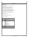
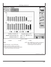
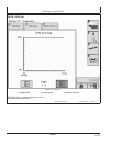
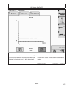
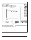
Satellite Tracking Information
Satellite Tracking information is displayed at bottom of
SKY PLOT and GRAPH tabs.
• Satellites in Solution – number of satellites used to
compute position.
• Satellites Above Elevation Mask – total number of
GPS satellites available to receiver that are above 7
degree elevation mask.
• Satellites Tracked – total number of GPS satellites
tracked by receiver.
• Corrections Age (sec) – age of differential correction
signal to GPS (normally less than 10 seconds)
• VDOP – Vertical Dilution of Precision
• HDOP – Horizontal Dilution of Precision
• PDOP – Positional Dilution of Precision is an
indicator of GPS satellite geometry as viewed by
receiver. A lower PDOP indicates better satellite
geometry for calculating both horizontal and vertical
position.
Continued on next page
15-21
121907
PN=29