


54 GPSMAP 400/500 Series Owner’s Manual
Conguring the Chartplotter
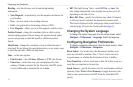
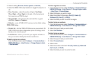
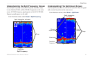
2. Use the Rocker to enter the measured distance from the
transducer location to the water line or to the keel of the boat.
If you are measuring down to the keel (transducer installed at
the water line), enter a (+) positive number. This shows the
depth at the bottom of the keel.
If you are measuring up to the water line (transducer installed
on the bottom of the keel), enter a (-) negative number. This
shows the depth at the surface.
3. Select Done to accept the number.
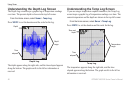
A (+) positive number
shows depth at the bottom
of the keel.
Transducer at Surface
A (-) negative number
shows depth at the
surface.
Transducer at the
Bottom of the Keel
Temp Offset—set the temperature offset for the temperature sensor
of your transducer.
•
•
Calibrate Water Speed—use this menu to calibrate a speed-sensing
device. Follow the on-screen directions for calibration. If you do not
have a speed-sensing device, this menu does not appear.
NOTE
: If the boat is not moving fast enough or the speed sensor
is not registering a speed, a “Speed Too Low” message appears.
Select OK, and safely increase the speed of the boat. If you get the
message again, stop the boat and make sure the speed-sensor wheel
is not stuck. If the wheel turns freely, check the cable connections. If
you continue to get the message, contact Garmin Product Support.
Fuel Capacity
—enter the total fuel capacity of your boat.
Conguring Other Vessels
To congure settings for boats other than your own, from the
Home screen, select Congure > Other Vessels.
NOTE: To congure AIS or DSC information for other boats, your
unit must be connected to an external AIS or DSC device.
AIS
—turn AIS (Automatic Identication System) on or off. AIS
alerts you to area trafc by providing boat IDs, position, course,
and speed for boats that are within range and equipped with a
transponder.
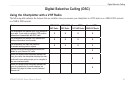
DSC
—turn DSC (Digital Selective Calling) on or off.