


GPSMAP 400/500 Series Owner’s Manual 45
Viewing Information
Proj. Heading—allows you to enter the projected heading
time for AIS-activated vessels.
Trails—shows the tracks of AIS vessels. Select the length of
the track that appears using a trail.
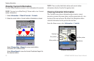
Activating a Target for an AIS Vessel
NOTE: Mariner’s Eye 3D charts are available only if you use a
BlueChart g2 Vision SD card. Fishing charts are available if you
use a BlueChart g2 Vision SD card or if your built-in map supports
Fishing charts.
1. From the Home screen, select Charts.
2. Select Navigation Chart, Fishing Chart, Perspective 3D, or
Mariner’s Eye 3D.
3. Use the Rocker to select an AIS vessel. Press SELECT.
4. Select AIS Vessel > Activate Target.
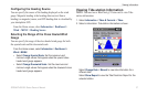
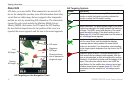
Viewing Information about a Targeted AIS Vessel
You can view the AIS signal status, MMSI, GPS speed, GPS
heading, and other information that is reported about a targeted AIS
vessel.
1. From the Home screen, select Charts.
2. Select Navigation Chart, Fishing Chart, Perspective 3D, or
Mariner’s Eye 3D.
3. Use the Rocker to select an AIS vessel. Press SELECT.
•
•
4. Select AIS Vessel.
Deactivating a Target for an AIS Vessel
NOTE: Mariner’s Eye 3D charts are available only if you use a
BlueChart g2 Vision SD card. Fishing charts are available if you
use a BlueChart g2 Vision SD card or if your built-in map supports
Fishing charts.
1. From the Home screen, select Charts.
2. Select Navigation Chart, Fishing Chart, Perspective 3D, or
Mariner’s Eye 3D.
3. Use the Rocker to select an AIS vessel. Press SELECT.
4. Select AIS Vessel > Deactivate.
Setting the Safe-zone Collision Alarm
The safe-zone collision alarm is used only with AIS. The safe zone
is used for collision avoidance, and can be customized. All safe-zone
collision alarm settings are applied to all charts and to all 3D chart
views.
1. From the Home screen, select Charts.
2. Select Navigation Chart, Fishing Chart, Perspective 3D, or
Mariner’s Eye 3D.