


GPSMAP 400/500 Series Owner’s Manual 43
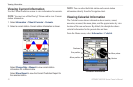
Viewing Information
The location of this symbol indicates the closest point of
approach to a dangerous target, and the numbers near the
symbol indicate the time to the closest point of approach
to that target.
Dangerous target is lost. A red X indicates that the AIS
transmission from the vessel is lost, and the chartplotter
displays a message banner asking whether the vessel
should continue to be tracked. If you discontinue vessel
tracking, the lost dangerous target symbol disappears from
the chart or the 3D chart view.
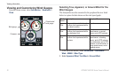
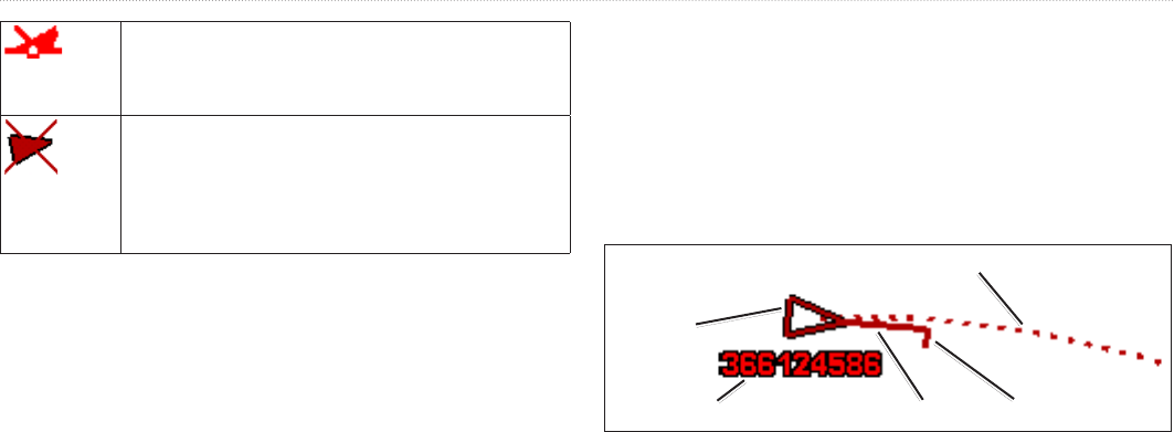
Heading and Projected Course of Activated AIS Targets
When course over ground and heading information are provided by
an activated AIS target, the heading of the target appears on a chart
as a solid line attached to the AIS target symbol. A heading line does
not appear on a 3D chart view.
The projected course of an activated AIS target appears as a dashed
line on a chart or a 3D chart view. The length of the projected course
line is based on the value of the projected heading setting (page 45).
If an activated AIS target is not transmitting speed information, or
if the vessel is not moving, a projected course line does not appear.
Changes in the speed, the course over ground, or the rate-of-turn
information transmitted by the vessel can impact the calculation of
the projected course line.
When course over ground, heading, and rate-of-turn information
are provided by an activated AIS target, the projected course of the
target is calculated based on the course over ground and the rate-of-
turn information. The direction in which the target is turning, which
is also based on the rate-of-turn information, is indicated by the
direction of the barb at the end of the heading line. The length of the
barb does not change.
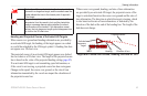
MMSI
Heading
Direction of turn
Projected course
Activated
dangerous
target
Target with Course over Ground, Heading, and Rate of Turn