


ii GPSMAP 400/500 Series Owner’s Manual
Introduction
Table of Contents
Introduction ...........................................................................i
Tips and Shortcuts ........................................................................ i
Manual Conventions ..................................................................... i
Quick Links ................................................................................... i
Declaration of Conformity (DoC) ..................................................iv
Product Registration ....................................................................iv
Contact Garmin ............................................................................iv
Getting Started .....................................................................1
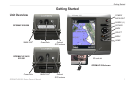
Unit Overview ............................................................................... 1
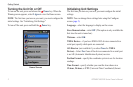
Turning the Unit On or Off ............................................................ 2
Initializing Unit Settings ................................................................ 2
Adjusting the Backlight ................................................................. 3
Using the Keypad ......................................................................... 4
Acquiring GPS Satellite Signals ................................................... 4
Using Simulator Mode .................................................................. 5
Viewing System Information ........................................................ 5
Restoring the Original Factory Settings ....................................... 5
Inserting and Removing SD Cards .............................................. 5
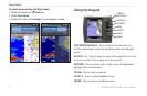
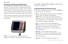
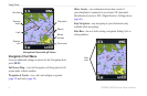
Understanding the Home Screen ................................................. 6
Using Charts ........................................................................7
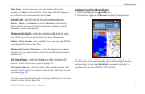
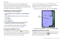
Using the Navigation Chart .......................................................... 7
Changing the Navigation Chart Settings .....................................11
Using the Split Navigation Chart ................................................ 14
Using Perspective 3D ................................................................ 14
Using Mariner’s Eye 3D ............................................................. 15
Using Fish Eye 3D ..................................................................... 17
Using Fishing Charts .................................................................. 17
Enabling High Resolution Satellite Imagery ............................... 18
Viewing Aerial Photos ................................................................ 19
Animated Tide and Current Indicators ....................................... 20
Detailed Road and POI Data ..................................................... 21
Using Automatic Guidance ......................................................... 21
Using the Chart/Sonar Screen ................................................... 22
Where To? ..........................................................................23
Navigating to a Destination ........................................................ 23
Creating and Using Waypoints................................................... 25
Creating and Using Routes ........................................................ 26
Using Tracks .............................................................................. 28
Using BlueChart g2 Vision ......................................................... 30
Navigating with a Garmin Autopilot ............................................ 30