


30 GPSMAP 400/500 Series Owner’s Manual
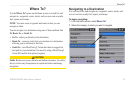
Where To?
Using BlueChart g2 Vision
NOTICE
BlueChart g2 Vision data cards are not waterproof. When you are
not using the card, keep it in the original packaging for safekeeping
and store it away from exposure to sun and rain to prevent damage
to the card.
BlueChart g2 Vision data cards are susceptible to damage from
static electricity. In low-humidity environments, you should ground
yourself on a large metal object before handling the card to prevent
damage to the card.
Optional BlueChart g2 Vision preprogrammed SD cards allow
you to get the most out of your unit. In addition to detailed marine
charting, BlueChart g2 Vision has the following features:
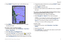
Mariner’s Eye 3D
—provides a view from above and behind the
boat for a three-dimensional navigation aid. The BlueChart g2
Vision Mariner’s Eye 3D is more detailed than the preloaded data
(page 15).
Fish Eye 3D
—provides an underwater 3D view that visually
represents the sea oor according to the information on the chart.
Fishing Charts
—provides a view of the chart with enhanced
bottom contours and without navigational data. This chart works
well for offshore deep-sea shing.
•
•
•
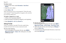
High Resolution Satellite Imagery—provides high-resolution
satellite images for a realistic view of the land and water on the
Navigation chart.
Aerial Photos
—provides a view of marinas and other
navigationally signicant aerial photos to help you visualize your
surroundings.
Detailed Roads and POI data
—provides a view of roads,
restaurants, and other points of interest (POIs) along the shore.
Current Data
—provides a view of current-station information
(page 38).
Auto Guidance
—uses the chart data and specied boat-safe
depth to determine the best course to your destination (page 49).
NOTE
: You cannot transfer BlueChart g2 Vision data from the SD
card to your computer for backup or viewing purposes. You can only
use the SD card on BlueChart g2 Vision-compatible Garmin GPS
units.
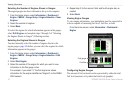
Navigating with a Garmin Autopilot
When you start any type of navigation (Go To, Route To, Guide
To, or Follow Track), if you are connected to a compatible Garmin
autopilot, you are prompted to engage the autopilot.
•
•
•
•
•