


46 GPSMAP 400/500 Series Owner’s Manual
Viewing Information
3. Select MENU > Other Vessels > AIS Alarm > On.
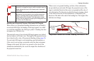
A message banner appears and an alarm sounds when an AIS-
activated vessel enters the safe-zone ring around your boat. The
object is also labeled as dangerous on the screen. The Off setting
disables the message banner and the audible alarm, but the object
is still labeled as dangerous on the screen.
4. Select Range to set the measured radius of the safe-zone ring to
a specied distance from 500 ft. to 2.0 nm (or from 150 m to 3.0
km, or from 500 ft. to 2.0 mi.).
5. Select a distance.
6. Select Time To to sound an alarm if AIS determines that a
target will intersect the safe zone within the dened time interval
(ranging from 1 to 24 minutes).
7. Select a time.
Viewing a List of AIS Targets
NOTE: Mariner’s Eye 3D charts and Fish Eye 3D charts are
available only if you use a BlueChart g2 Vision SD card. Fishing
charts are available if you use a BlueChart g2 Vision SD card or if
your built-in map supports Fishing charts.
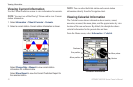
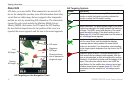
The AIS target list shows information about all of the boats your
unit is monitoring. The AIS list shows the MMSIs or (if the boat is
broadcasting it) names of the AIS boats and is sorted by range. The
boat nearest to your boat appears at the top of the list.
1. From the Home screen, select Charts.
2. Select Navigation Chart, Fishing Chart, Perspective 3D, or
Mariner’s Eye 3D.
3. Select MENU > Other Vessels > AIS List.
Making a Call to an AIS Target
See “Calling an AIS Target” (page 65).