


44 GPSMAP 400/500 Series Owner’s Manual
Viewing Information
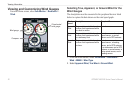
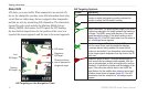
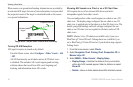
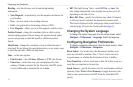
When course over ground and heading information are provided by
an activated AIS target, but rate-of-turn information is not provided,
the projected course of the target is calculated based on the course
over ground information.
MMSI
Heading
Projected course
Activated
target
Target with Course over Ground and Heading
Turning Off AIS Reception
AIS signal reception is turned on by default.
From the Home screen, select Congure > Other Vessels > AIS
> Off.
All AIS functionality on all charts and on all 3D chart views
is disabled. This includes AIS vessel targeting and tracking,
collision alarms that result from AIS vessel targeting and
tracking, and information about AIS vessels.
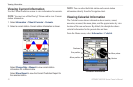
Showing AIS Vessels on a Chart or on a 3D Chart View
AIS requires the use of an external AIS device and active
transponder signals from other vessels.
You can congure how other vessels appear on a chart or on a 3D
chart view. The display range congured for one chart or one 3D
chart view is applied only to that chart or to that 3D chart view. The
details, projected heading, and trails settings congured for one
chart or one 3D chart view are applied to all charts and to all 3D
chart views.
NOTE
: Mariner’s Eye 3D charts are available only if you use a
BlueChart g2 Vision SD card. Fishing charts are available if you
use a BlueChart g2 Vision SD card or if your built-in map supports
Fishing charts.
1. From the Home screen, select Charts.
2. Select Navigation Chart, Fishing Chart, Perspective 3D, or
Mariner’s Eye 3D.
3. Select MENU > Other Vessels > Display Setup.
Display Range—indicates the distance from your location
within which AIS vessels appear. Select a distance or select
Show All.
Details—shows or hides details about AIS-activated vessels.
•
•