


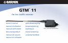
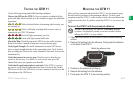

GTM 11 Owner’s Manual EN-5
E
N
E
N
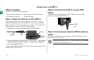
USING TRAFFIC DATA WITH YOUR GARMIN GPS DEVICE
The GTM 11 works with your Garmin GPS device to show traffic flow
and incident information and enable routing around the traffic incident.
Although each GPS device operates differently, they all provide the same
basic traffic information.
NOTE: The GTM 11 and GPS device must be in data range of an
FM station transmitting TMC data to receive traffic information.
NOTE: Garmin is not responsible for the accuracy of the traffic
information. The GTM 11 simply receives signals from the traffic
service provider and shows that information on your GPS device.
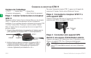
Avoiding Traffic
The map page shows a when there is a traffic incident on your current
route or on the road you are traveling on. Touch the
to view the traffic
information for the road. Touch a traffic incident to avoid it.
Viewing Traffic Information
Each GPS device lists the traffic incidents that are near your current
location. On many GPS devices, you can access this list from the Menu
page. Touch Tools
and then touch Traffic Info. Touch an item in the Traffic
Info list to view the details.
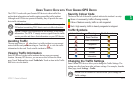
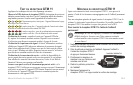
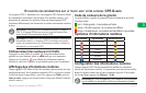
Severity Colour Code
The bars to the left of the traffic symbols indicate the incident’s severity:
Green = Low severity; traffic is flowing normally.
Yellow = Medium severity; traffic is a bit congested.
Red = High severity; traffic is heavily congested or stopped.
Traffic Symbols
International Meaning North American
Road Condition
Road Construction
Congestion
Accident
Incident
Information
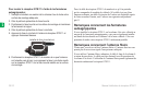
Changing the Traffic Settings
Some Garmin GPS devices allow you to change the Traffic Settings. The
settings are often found near other software settings. For example, from the
Menu page, touch Settings > Traffic.
NOTE: Not all Garmin GPS devices allow you to change the
Traffic settings.