


GPSMAP 400/500 Series Owner’s Manual 39
Conguring the Chartplotter
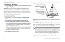
Safe Height—set the minimum height (chart height datum) of a
bridge that your boat can safely travel under.
Shoreline Distance
—set the safe distance for your boat from the
shore: Nearest, Near, Normal, Far, or Farthest.
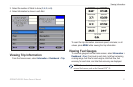
Conguring Communications Settings
To change the communications settings from the Home screen,
select Congure > Communications.
Serial Port 1—congures the input/output format for serial port 1 to
use when connecting your chartplotter to external NMEA devices, a
computer, or other Garmin devices.
Serial Port 2 (if supported)—congures the input/output format for
serial port 2 to use when connecting your chartplotter to external
NMEA devices, a computer, or other Garmin devices.
Garmin Data Transfer
—supports the input or output of
Garmin-proprietary data for communicating with Garmin
software.
Garmin Remote Sonar Transfer
(GPSMAP
420/450/520/550/525/555)—supports the input or output of
Garmin-proprietary sonar data for communicating with Garmin
software.
•
•
•
•
NMEA Standard—supports the input or output of standard
NMEA 0183 data, DSC, and sonar NMEA input support for the
DPT, MTW, and VHW sentences.
NMEA High Speed
—supports the input or output of standard
0183 data for most AIS receivers.
NMEA 0183 Setup
—enable or disable NMEA 0183 output
sentences for sounder, route, system, and Garmin NMEA settings.
To enable or disable NMEA 0183 output sentences:
1. From the Home screen, select Congure > Communications >
NMEA 0183 Setup.
2. Select a setting (Sounder, Route, System, or Garmin).
3. Select the NMEA 0183 output sentence to toggle the output on or
off.
Posn. Precision—adjust the number of digits (Two Digits,
Three Digits
, or Four Digits) to the right of the decimal point
for transmission of NMEA output.
Waypoint IDs
—determine how the unit identies waypoint
identiers (Names or Numbers).
•
•
•
•