A SERVICE OF

logo

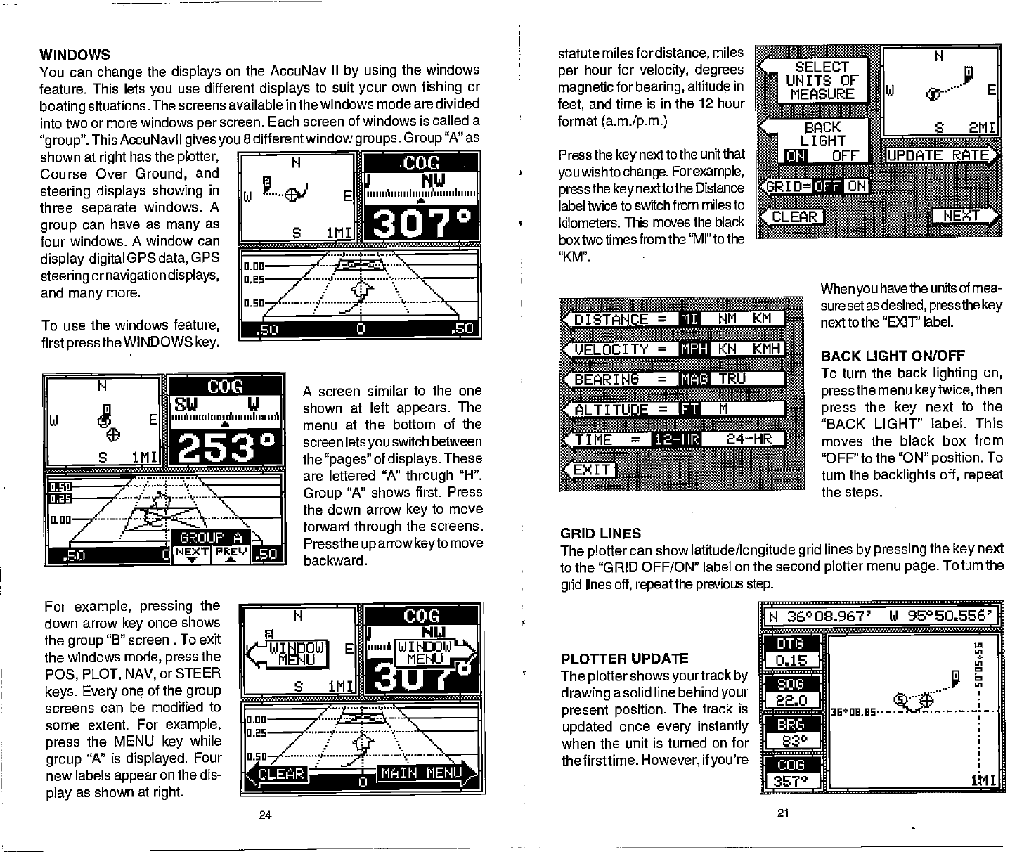
WINDOWS
You
can
change
the
displays
on the AccuNav
II
by
using
the windows
feature. This lets
you
use different
displays
to suit
your
own
fishing
or
boating
situations. The screens
available in the
windows mode are divided
into two or more windows
per
screen. Each screen of
windows is called a
"group".
This AccuNavil
givesyou
8 differentwindow
groups.
Group
"A" as
shown
at
right
has the
plotter,
Course Over
Ground,
and
steering displays showing
in
three
separate
windows.
A
group
can have as
many
as
four windows. A window can
display digital
GPS
data,
GPS
steering
ornavigation displays,
and
many
more.
To use the windows
feature,
first
pressthe
WINDOWS
key.
For
example, pressing
the
down
arrow
key
once shows
the
group
"B" screen . To exit
the windows
mode, press
the
P03, PLOT, NAV,orSTEER
keys.
Every
one of the
group
screens
can be modified to
some extent.
For
example,
press
the MENU
key
while
group
"A"
is
displayed.
Four
new labels
appear
on the dis-
play
as shown
at
right.
' ' ' ' ' '
' ' ' I , ;, t
..-..-.
A screen
similar to the one
shown at
left
appears.
The
menu
at the bottom of the
screen lets
you
switch between
the
"pages"
of
displays.
These
are leftered
"A"
through
"H".
Group
"A" shows
first. Press
the down arrow
key
to move
forward
through
the screens.
Pressthe
uparrowkeyto
move
backward.
statute
milesfordistance,
miles
per
hour for
velocity, degrees
magnetic
for
bearing,
altitude
in
feet,
and time is in the 12 hour
format
(a.m./p.m.)
Press
the
key
next to the unit that
you
wish to
change.
For
example,
press
the
key
next
to the Distance
label twice to
switch from miles to
kilometers. This moves
the black
box two times from
the "Ml" to the
"KM'.
When
you
have the units of mea-
suresetasdesired, pressthekey
next to
the "EXIT' label.
BACK LIGHT ON/OFF
To turn the back
lighting
on,
pressthe
menu
keytwice,then
press
the
key
next to
the
"BACK LIGHT"
label. This
moves the black box from
"OFF" to the "ON"
position.
To
turn the
backlights
off,
repeat
the
steps.
GRID LINES
The
plotter
can show
latitude/longitude grid
lines
by
pressing
the
key
next
to the "GRID OFF/ON" label
on the second
plotter
menu
page.
Totumthe
grid
lines
off,
repeat
the
previous
step.
PLOTTER UPDATE
The
plotter
shows
yourtrack
by
drawing
a solid line
behind
your
present position.
The track is
updated
once
every
instantly
when the unit is turned
on for
thefirsttime.
However,
if
you're
IN
36°08.967' hi 96°EU.656'
0.1111
:zJ:!::::::::x:::..'
r-b13
1—
—I
a:
r
COG
Th.
'a
Ui
In
C
24
21
iiii
PDF compression, OCR, web-optimization with CVISION's PdfCompressor